US Map / US Time Zones
US Time Zones Map
The United States spans six time zones. Here's the map, the states in each zone, and the states that split across two.
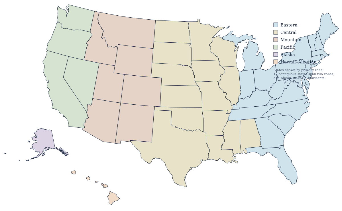
The six US time zones
| Zone | UTC offset | States wholly in | States partly in |
|---|---|---|---|
| Eastern (ET) | −5 / −4 | 17 | 5 |
| Central (CT) | −6 / −5 | 10 | 10 |
| Mountain (MT) | −7 / −6 | 6 | 8 |
| Pacific (PT) | −8 / −7 | 2 | 3 |
| Alaska (AKT) | −9 / −8 | — | 1 |
| Hawaii–Aleutian (HAT) | −10 (no DST in Hawaii) | 1 | 1 |
Which time zone is my state in?
Thirty-six states keep one clock from border to border; the other fourteen are cut by a zone line somewhere. The table below gives every state and the zone it uses, and where a state is split, the zone most of its population lives in comes first.
States split between two zones
Thirteen of the contiguous states are divided by a time zone boundary, and Alaska makes a fourteenth. Florida keeps its western panhandle on Central and the peninsula on Eastern; Indiana puts a dozen counties near Chicago and Evansville on Central and the rest on Eastern; Tennessee and Kentucky both split east–west between the same two zones; Texas gives only El Paso and Hudspeth counties to Mountain. Michigan, the Dakotas, Nebraska, Kansas, Idaho and Oregon are the rest of the thirteen. Nevada is the narrowest split in the country — one town, West Wendover, sits on the Utah line and runs on Mountain time while the entire rest of the state is Pacific. Alaska is the fourteenth: everything but the far western Aleutians is on Alaska Time, and those islands keep Hawaii–Aleutian. The map above colors each state by its primary zone only, so for a split state check its own page from the states index.
Daylight saving time
Most of the country moves clocks forward one hour from March to November. Two places don't: Hawaii, and Arizona outside the Navajo Nation. During DST, Arizona matches Pacific Daylight Time even though it sits in the Mountain zone — a frequent source of confusion for anyone booking meetings with Phoenix.
Reading the zone boundaries
Time zone lines rarely follow straight meridians. They bend around state borders, metro areas, and even individual counties so that communities that trade together keep the same clock. That's why the Central–Mountain boundary zigzags through the Great Plains rather than cutting cleanly down the map.
Who decides where the lines run
Not the states. Zone boundaries are federal, set by the Department of Transportation under the Standard Time Act, and a county that wants to switch has to petition for a rulemaking and show that its economic life points the other way. Counties do it regularly and the map keeps moving: the western half of the Dakotas, Nebraska and Kansas belongs to Mountain Time because ranching country there looks to Denver rather than Omaha, and several Indiana counties have changed zones more than once as commuting patterns shifted toward Chicago or Louisville.
The zones in practice
Roughly half the country's population lives in the Eastern zone, which is why national broadcasts and market hours are quoted in it, and it also holds the most states — 17 wholly inside it against Central's 10. The Central zone's distinction is the opposite one: ten of the fourteen split states touch it, more than any other zone, because it is the only zone with a neighbor on each side across the whole width of the country. Mountain is the thinnest by population, and it is the only one where a large state — Arizona — keeps standard time year-round, so it effectively joins Pacific for half the year. Beyond the mainland, Alaska puts almost an entire state on one clock despite spanning as much longitude as the lower 48, and Hawaii–Aleutian observes no daylight saving in Hawaii, where day length barely changes across the year.