US Map / US Regions
US Regions Map
The Census Bureau divides the 50 states into four regions and nine divisions. This is the grouping used on weather maps, in statistics, and across this site.
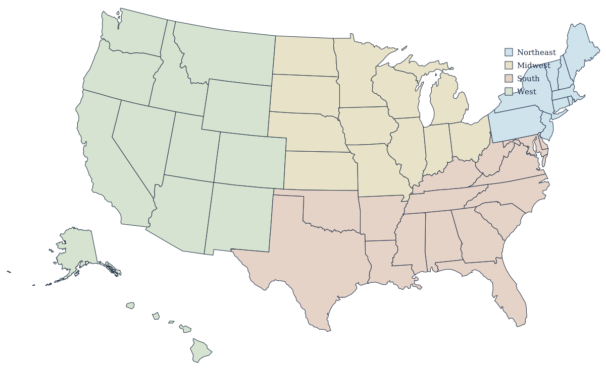
The four regions and their states
| Region | Division | States |
|---|---|---|
| Northeast | New England | CT, ME, MA, NH, RI, VT |
| Mid-Atlantic | NJ, NY, PA | |
| Midwest | East North Central | IL, IN, MI, OH, WI |
| West North Central | IA, KS, MN, MO, NE, ND, SD | |
| South | South Atlantic | DE, FL, GA, MD, NC, SC, VA, WV (+ DC) |
| East South Central | AL, KY, MS, TN | |
| West South Central | AR, LA, OK, TX | |
| West | Mountain | AZ, CO, ID, MT, NV, NM, UT, WY |
| Pacific | AK, CA, HI, OR, WA |
Regions people use informally
Everyday regional names don't always match the Census map. "The Southwest" usually means Arizona and New Mexico with parts of Texas, Nevada, and California. "The Pacific Northwest" is Washington and Oregon, sometimes with Idaho. "New England" is the one informal name that matches its Census division exactly. "The Great Plains" and "the Rust Belt" describe geography and economic history rather than any official boundary — for the physical side of those names, see the geography maps.
Why the Census groups matter
These four regions are the standard breakdown in federal statistics, so population, housing, and economic figures you see in the news are usually reported this way. That's also why Maryland and Delaware count as "South" even though most residents would say otherwise — the definitions were fixed in the 1900s and have barely changed since.
The four regions at a glance
The West is the largest by area and holds the biggest and the emptiest states at once — Alaska and Wyoming. The South is the largest by population and by state count, with 16 states running from Delaware to Texas. The Midwest holds 12 states split between the Great Lakes and the Plains. The Northeast has only nine, and all of New England would fit inside Montana — but it is the densest part of the country, and the corner where most people lose points on the map quiz.
Regions versus divisions
The nine divisions are the more useful unit when a four-way split is too coarse. They are what separates the industrial East North Central states from the agricultural West North Central ones, and what distinguishes the Atlantic seaboard of the South Atlantic from the Gulf and prairie states of the West South Central. Federal agencies publish at both levels, so a statistic quoted "for the Midwest" and one quoted "for the East North Central division" can differ by seven states.