US Map / Time Zones / Eastern Time
Eastern Time Zone Map
About half the US population sets its clocks by this zone. Here is every state in it, the five that are only half in, and the offsets.
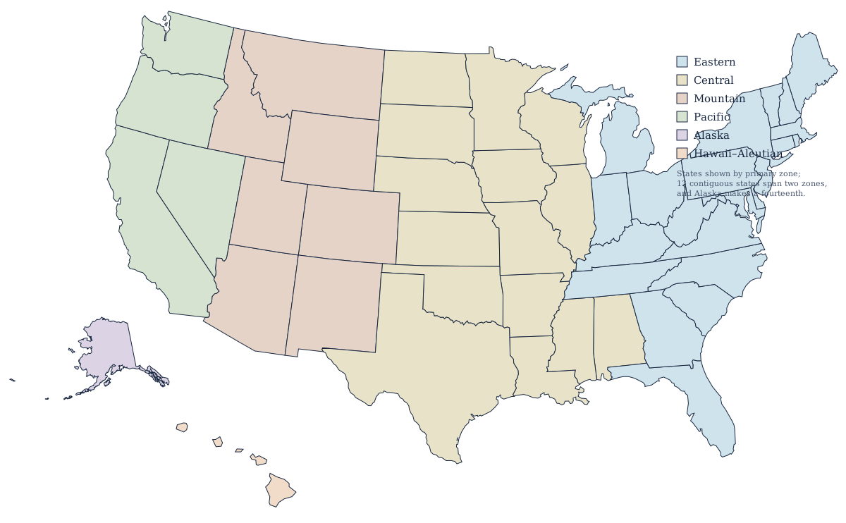
Which states are on Eastern Time?
Seventeen states plus the District of Columbia sit entirely inside the Eastern zone, and five more are split with Central Time. That makes Eastern the most populous time zone in the country by a wide margin — roughly half of all Americans set their clocks by it, including everyone in New York, Washington, Miami, and Atlanta.
- Connecticut
- Delaware
- Georgia
- Maine
- Maryland
- Massachusetts
- New Hampshire
- New Jersey
- New York
- North Carolina
- Ohio
- Pennsylvania
- Rhode Island
- South Carolina
- Vermont
- Virginia
- West Virginia
Every state above is Eastern from border to border. Michigan and Indiana appear on the split list below even though the great majority of both keeps Eastern Time: a state counts as split here if any of its counties are on another clock, however few of them there are.
The five states only partly on Eastern Time
Florida splits along the Apalachicola River: the panhandle west of it, including Panama City and Pensacola, is Central, while Tallahassee and everything on the peninsula is Eastern. Indiana has twelve Central counties, six in the northwest inside the Chicago commuting area and six in the southwest around Evansville; the other eighty are Eastern, Indianapolis among them. Kentucky splits close to its middle and Tennessee along the Cumberland Plateau, about a third of the way in from its eastern end: Louisville, Lexington, Knoxville, and Chattanooga keep Eastern time, while Bowling Green, Paducah, Nashville, and Memphis are Central. In Michigan, four counties in the western Upper Peninsula — Gogebic, Iron, Dickinson, and Menominee — run on Central time to match Wisconsin next door; the rest of the state is Eastern.
UTC offset: EST and EDT
| Standard time (EST) | UTC−5, roughly November to March |
| Daylight time (EDT) | UTC−4, roughly March to November |
| Clocks forward | 2:00 a.m. on the second Sunday in March |
| Clocks back | 2:00 a.m. on the first Sunday in November |
| States wholly in the zone | 17, plus the District of Columbia |
| States partly in the zone | Florida, Indiana, Kentucky, Michigan, Tennessee |
Daylight saving time begins at 2:00 a.m. local time on the second Sunday in March and ends at 2:00 a.m. on the first Sunday in November. Those dates are newer than most people realize: the Energy Policy Act of 2005 moved the start forward from the first Sunday in April and the end back from the last Sunday in October, and the longer schedule first ran in 2007. Every state in the Eastern zone observes it, and there is no Arizona-style holdout on this side of the country. The zone is also more than 20 degrees of longitude wide, from eastern Maine to the Lake Superior shore of Michigan, so the sun sets more than an hour later at its western edge than at its eastern one on the same clock.
Where the Eastern boundary runs
From north to south the line leaves the Canadian border in the middle of Michigan's Upper Peninsula, runs down Lake Michigan, cuts across northwestern Indiana, then swings east and south through Indiana and Kentucky, down the eastern flank of the Cumberland Plateau in Tennessee, south along the Georgia–Alabama state line, and finally out to the Gulf along the Apalachicola in Florida. It is drawn on county lines and river channels, never on a meridian, because the Department of Transportation sets it by where communities do business rather than by where the sun happens to be. That is why it splits Florida's Gulf County along the river rather than around it, and why Ontonagon County on Michigan's Lake Superior shore keeps Eastern Time while Menominee County, well to its southeast, keeps Central.
The other zones
West of here is Central Time, then Mountain, Pacific, Alaska, and Hawaii–Aleutian — six in all, laid out together on the US time zones map. Most of the zone falls inside the Northeast and the South.