US Map / Labeled US Map
Labeled US Map of the United States
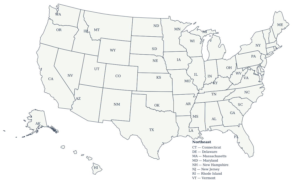
Hover any state below for its name, abbreviation, and capital. The printable version carries the two-letter code on every state, with the crowded northeastern corner named in a key.
Reading the labeled map
The interactive map and the printable file label the states differently, because a screen and a sheet of paper have different amounts of room. On the map above, hovering a state calls up its full name, its two-letter abbreviation and its capital, and clicking opens that state's own page. The downloadable file has no hover to fall back on, so it does what a printed reference map does: it sets the two-letter code inside each state and names the eight it cannot fit in a key at the lower right. Knowing the codes is what makes that file — or any printed map at country scale — readable at a glance.
Where the labels sit on the map
Each code on the printable map is placed at the center of the largest single piece of the state rather than at the state's mathematical centroid, because a centroid describes an average and not a shape. Hawaii is the case that proves it: its centroid falls in open ocean between Maui and the island of Hawaii, where no label could sit, while the largest-piece rule puts HI on the island of Hawaii, which is at least land. It is also the only one of the 50 whose centroid lands outside its own borders — everywhere else the two methods agree closely enough that you would not notice. Michigan defeats both rules anyway, being two peninsulas with open water between them and no single point that speaks for both.
States that are easy to mix up
A few pairs trip nearly everyone up: Mississippi and Alabama sit side by side with similar shapes; Colorado and Wyoming are both rectangles (Wyoming is the more northern one); and New Hampshire and Vermont mirror each other, with Vermont on the west. The map quiz is the quickest way to make these stick.
The eight states that need a key
A label has to fit inside the shape it names, and eight states are too narrow at country scale for that: Connecticut, Delaware, Maryland, Massachusetts, New Hampshire, New Jersey, Rhode Island and Vermont. Published maps solve it one of two ways — set the abbreviation out in the Atlantic and run a thin leader line back to the state, or list the eight in a key and leave the map itself clean. The printable file here takes the second route, because leader lines are the first thing to break when someone rescales an SVG or prints it at 80%. Maryland is the hardest case in the country either way: the state narrows to under two miles near Hancock and then widens again around the Chesapeake, so neither half has room for a name.
Related maps
For the reverse exercise, use the blank US map and fill in the names yourself. To see capitals rather than state names, open the US map with capitals, and for the biggest metro areas see the US map with cities. The labeled map doubles as the answer key for any of them, which is why the classroom worksheet guide pairs it with the blank version.