US Map / Geography / Appalachian Mountains
Appalachian Mountains Map
Mount Mitchell, 6,684 feet, is the highest ground in the United States east of the Mississippi.
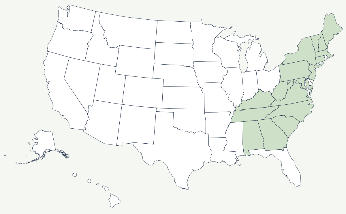
The Appalachians run about 1,500 miles from central Alabama to the Gulf of St Lawrence, and they are old — worn down, rounded and forested, with no glaciers and no bare rock above treeline south of New England. They are also arranged in remarkably straight parallel belts, which is why a road map of Pennsylvania or Virginia shows highways zigzagging between ridges instead of crossing them.
Which states do the Appalachian Mountains run through?
The physiographic range begins in central Alabama, where Cheaha Mountain (2,413 ft, the state's high point) tops the Talladega range, carries on through northwest Georgia, clips the corner of South Carolina, and reaches its greatest height in western North Carolina and eastern Tennessee. It carries north through Kentucky, Virginia and all of West Virginia, across western Maryland and the whole diagonal width of Pennsylvania, through a corner of New Jersey and up the eastern edge of New York. The northern continuation runs through Connecticut and Massachusetts as the Berkshires, Vermont as the Green Mountains, New Hampshire as the Whites, and Maine to Katahdin. The Appalachian Regional Commission uses a wider economic definition — thirteen states, including eastern Ohio and northeast Mississippi — of which only West Virginia lies entirely inside.
| Peak | State | Elevation |
|---|---|---|
| Mount Mitchell | North Carolina | 6,684 ft |
| Kuwohi (Clingmans Dome) | Tennessee | 6,643 ft |
| Mount Washington | New Hampshire | 6,288 ft |
| Mount Rogers | Virginia | 5,729 ft |
| Katahdin | Maine | about 5,270 ft |
| Spruce Knob | West Virginia | 4,863 ft |
| Brasstown Bald | Georgia | 4,784 ft |
| Black Mountain | Kentucky | 4,145 ft |
Notable places along the range
Mount Mitchell stands in the Black Mountains of North Carolina, a spur off the Blue Ridge, and carries a spruce-fir forest that belongs climatically to Canada. Mount Washington, in the Presidential Range, is far lower but far more exposed: three storm tracks converge on it, and the 231 mph gust recorded at its summit observatory in 1934 stood as the world record for a surface wind measured by a manned station for over sixty years. Between the two runs the Appalachian Trail, roughly 2,190 miles from Springer Mountain in Georgia to Katahdin in Maine — the exact figure changes every year as sections are relocated. The Blue Ridge Parkway and Skyline Drive follow the crest for 574 miles through Virginia and North Carolina.
The barrier, and the gaps that broke it
For a century and a half the range held the English colonies against the coast. There was no easy crossing between the Mohawk Valley and Georgia, and the Proclamation of 1763 made the crest a legal boundary as well as a physical one, forbidding settlement beyond it. Everything that followed depended on finding the few weak points. The Cumberland Gap, a saddle at about 1,600 feet where Kentucky, Virginia and Tennessee meet, was widened into the Wilderness Road in 1775 and carried perhaps 300,000 settlers into Kentucky and Tennessee before 1810. In the north, the Mohawk Valley is the only break in the entire chain near sea level, and the Erie Canal used it in 1825 to connect the Hudson to the Great Lakes — the single decision that made New York rather than Philadelphia or Baltimore the country's dominant port. The plateau behind the ridges held the bituminous coalfield that built Pittsburgh, and the company towns of West Virginia and eastern Kentucky were laid out along the creeks that reached the seams.
The range's highest section has its own page, the Great Smoky Mountains, and its worn southwestern outlier is covered by the Ozarks map. Rivers that drain it include the Ohio and the Tennessee, and its eastern foot is the Atlantic Coast. See the physical geography of the United States, or the state pages for North Carolina and West Virginia.