US Map / Geography / Tennessee River
Tennessee River Map
The Tennessee leaves its own state, crosses Alabama, clips Mississippi, and comes back.
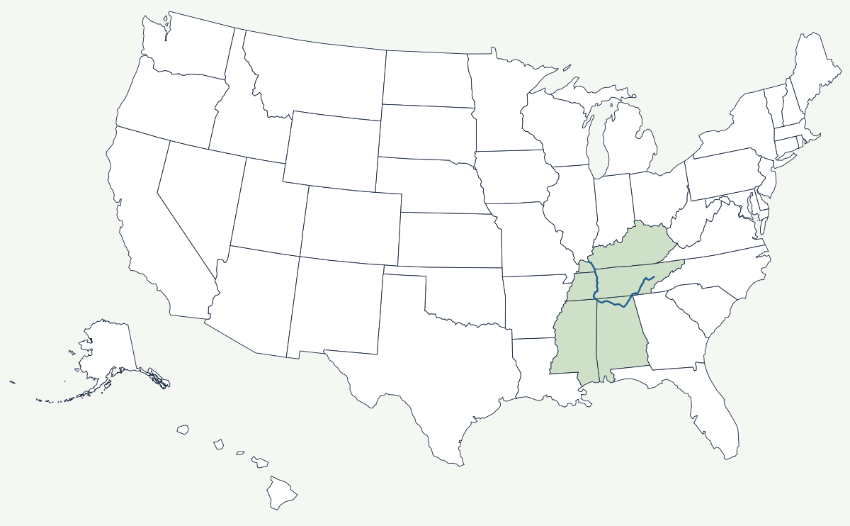
The Tennessee is formed at Knoxville, where the Holston and the French Broad meet, and runs 652 miles to the Ohio at Paducah. Its shape on the map is a deep U: southwest through eastern Tennessee, west across northern Alabama, then north again through Tennessee to Kentucky. No other major river in the country makes that turn, and the reason is the folded rock of the southern Appalachians steering it around the end of the ridges.
Which states does the Tennessee River cross?
Four on the main stem. From Knoxville the river flows southwest through Tennessee past Chattanooga, where it cuts the Tennessee River Gorge through Walden Ridge. It crosses into Alabama above Guntersville and runs west past Decatur and the Muscle Shoals towns. At Pickwick Lake it touches the northeast corner of Mississippi — a short reach, but a real one — then turns north, re-enters Tennessee, and crosses into Kentucky for the last stretch to the Ohio. The drainage basin is wider than the channel: it also takes water off the mountains of North Carolina, Virginia and Georgia.
| Head | Knoxville, Tennessee — confluence of the Holston and French Broad |
| Mouth | Ohio River at Paducah, Kentucky |
| Length | 652 miles |
| Drainage basin | about 40,900 square miles in seven states |
| States on the main stem | Tennessee, Alabama, Mississippi, Kentucky |
| Managing agency | the Tennessee Valley Authority, created by Congress in 1933 |
| First TVA dam | Norris Dam, on the Clinch River, completed 1936 |
| Lowest dam | Kentucky Dam, which impounds Kentucky Lake |
Notable places along the river
At Chattanooga the river swings around Moccasin Bend and squeezes into a gorge between Signal Mountain and Lookout Mountain — the reach nineteenth-century boatmen called the Suck, and the reason control of Chattanooga mattered so much in 1863. In northwest Alabama the Muscle Shoals were a long stretch of rapids that stopped steamboats altogether; the federal government dammed them at Wilson Dam during the First World War to power nitrate plants, and the decade-long argument over what to do with the idle plants afterwards produced the TVA. At the far end, Kentucky Dam and the Cumberland's Barkley Dam impound two lakes separated by a narrow strip of land, joined by a canal and set aside as Land Between the Lakes. Of Tennessee's four largest cities, two sit on this river; Nashville is on the Cumberland and Memphis on the Mississippi.
How the TVA rebuilt the valley
Before 1933 the Tennessee flooded badly, ran too shallow to navigate above Muscle Shoals, and served a valley where most farms had no electricity. The Tennessee Valley Authority was given the whole watershed as a single unit — an unusual grant of authority, and one that made the river a test case for regional planning. It built a chain of main-stem dams that hold a nine-foot navigation channel for all 652 miles, along with tributary storage dams for flood control, and sold the power at rates that put lines down farm roads private utilities had skipped. The consequences went well beyond farming: Oak Ridge was sited in these hills in 1942 in part because TVA could supply the enormous electrical load the uranium plants needed, and aluminium smelting and chemical works followed the same cheap power. The cost was borne by the towns and farms flooded by the reservoirs, and by the free-flowing river itself, which now exists only above Knoxville.
The Tennessee is the largest tributary of the Ohio River and therefore part of the Mississippi system. Its headwaters rise in the Great Smoky Mountains and the wider Appalachian Mountains. See the physical geography of the United States, or the state pages for Tennessee and Alabama.