US Map / County Maps / Washington
Washington County Map
King County was named in 1852 for a slaveholding vice president, and in 1986 it decided to be named for Martin Luther King Jr. instead.
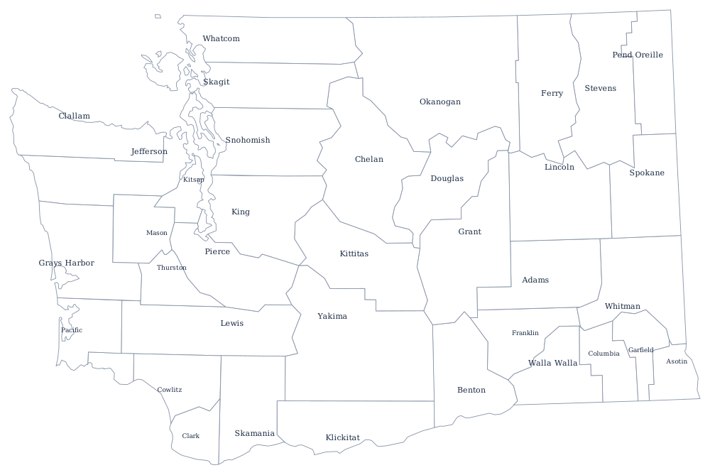
Washington's counties began as Oregon Territory counties north of the Columbia and were added to steadily until 1911, when Pend Oreille was cut from Stevens County. The Cascade Range divides them as sharply as it divides the rainfall: the counties west of the crest hold about three quarters of the state's population on a third of its land, and the eastern counties are wheat, orchards, and shrub-steppe.
The 39 counties of Washington
King, Pierce, and Snohomish are the Puget Sound urban core and hold 52% of the state between them. The ten below come to 82%.
| County | County seat | Population (2024 estimate) |
|---|---|---|
| King County | Seattle | 2,340,211 |
| Pierce County | Tacoma | 941,170 |
| Snohomish County | Everett | 864,113 |
| Spokane County | Spokane | 555,947 |
| Clark County | Vancouver | 527,269 |
| Thurston County | Olympia | 302,912 |
| Kitsap County | Port Orchard | 281,420 |
| Yakima County | Yakima | 258,523 |
| Whatcom County | Bellingham | 234,954 |
| Benton County | Prosser | 218,190 |
A county that renamed itself, and a law that draws its edges
King County was named in 1852 for William Rufus King, then vice president-elect and an Alabama slaveholder. In 1986 the county council voted to rededicate the name to Martin Luther King Jr.; the state legislature confirmed the change in 2005, and the county replaced its crown logo with King's portrait in 2007. It is the only county in the country to have changed the person it is named after while keeping the name.
What most shapes Washington counties day to day is the Growth Management Act of 1990. It requires the larger and faster-growing counties to write comprehensive plans, designate urban growth areas beyond which urban development may not go, and protect farmland and critical areas — and it created a set of regional hearings boards that can invalidate a county's plan. The visible result is that the edge of suburban development around Puget Sound is a line drawn by county planners rather than by the market. Seven counties, including King, Pierce, Snohomish, and Whatcom, have adopted home rule charters with elected executives and councils; the rest are run by three commissioners.
Largest and smallest counties
King County is the most populous at 2,340,211 in the 2024 estimates — 29% of the state — and contains Seattle. Pierce County is second at 941,170 with Tacoma. The smallest is Garfield County in the south-east wheat country, 2,404 people, with its courthouse at Pomeroy. Okanogan County, which runs from the Cascade crest to the Canadian border, is the largest by land area at about 5,270 square miles — larger than Connecticut.
Continue to the Washington state page or the county map index. Washington touches only Oregon and Idaho, though Alaska is the other Pacific coast state with a county map worth comparing. The Cascade Range page explains the crest that divides the state in two.