US Map / County Maps / Oregon
Oregon County Map
Oregon's counties were created by a provisional government in 1843, five years before there was a territory to put them in.
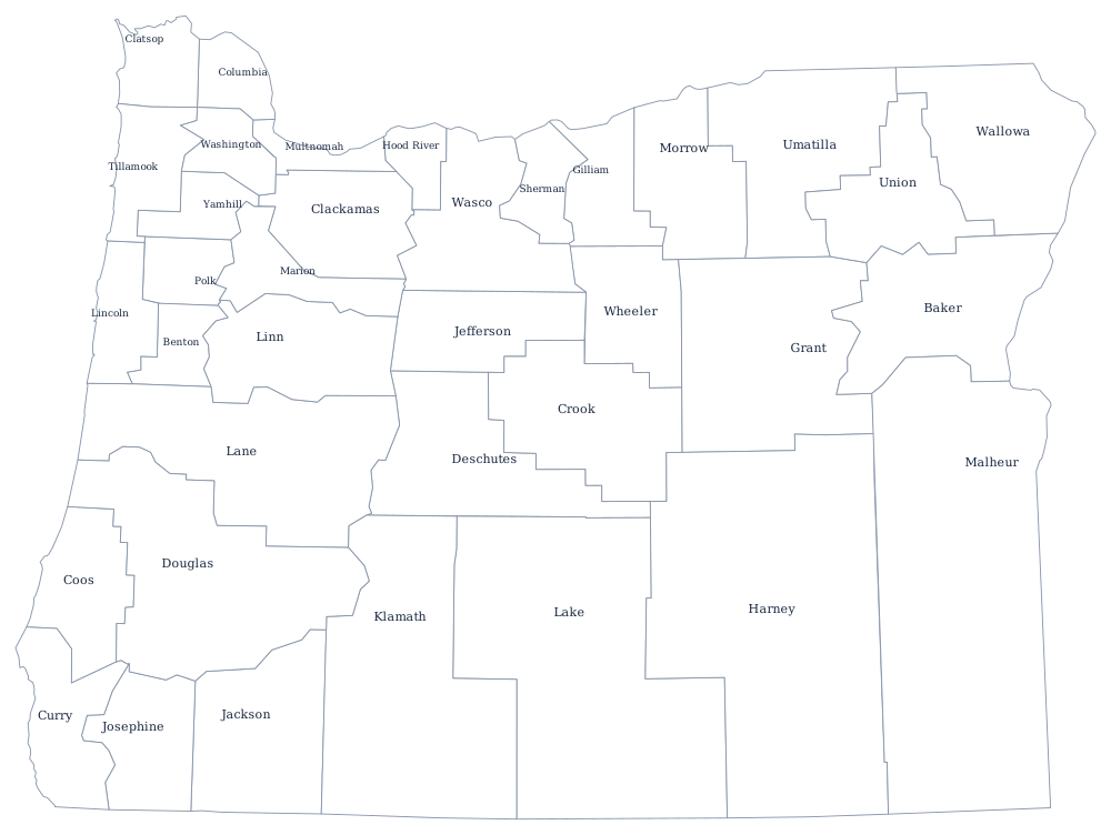
The settlers at Champoeg voted in 1843 to organize a provisional government, and one of its first acts was to divide the Oregon Country into four districts: Twality, Clackamas, Yamhill, and Champooick. All four are still counties, two of them under those names. The rest were split off as the valley filled and the eastern rangeland was claimed, and the last, Deschutes, was cut from Crook County in 1916 after the railroads reached Bend.
The 36 counties of Oregon
Multnomah County is the smallest county in Oregon by land area and the largest by population. With Washington and Clackamas it makes up the Portland metropolitan area, and the three hold 43% of the state.
| County | County seat | Population (2024 estimate) |
|---|---|---|
| Multnomah County | Portland | 795,897 |
| Washington County | Hillsboro | 611,272 |
| Clackamas County | Oregon City | 425,857 |
| Lane County | Eugene | 382,396 |
| Marion County | Salem | 352,867 |
| Jackson County | Medford | 221,331 |
| Deschutes County | Bend | 211,535 |
| Linn County | Albany | 132,474 |
| Douglas County | Roseburg | 112,255 |
| Yamhill County | McMinnville | 110,886 |
When the timber money stopped
More than half of Oregon is federal land, and for most of the twentieth century the counties were paid for it. Under the 1937 O&C Act, eighteen western Oregon counties received a share of the receipts from logging the revested Oregon and California Railroad lands — in some counties enough to fund the sheriff, the roads, and the libraries with property tax rates among the lowest in the country. Timber harvests on federal land collapsed in the early 1990s, Congress replaced the receipts with declining transitional payments, and those expired.
The consequences fell hardest on the south-west. Curry County and Josephine County came close to insolvency in the 2010s; Josephine County voters repeatedly rejected levies to replace the lost federal money, and the sheriff's office cut patrols to weekday daytime hours and stopped responding to some property crimes. Oregon counties may adopt home rule charters, and nine have, giving them elected commissions or chairs and some ordinance power; the rest run under general law with three commissioners and a county court in the smallest ones, where the county judge still sits on both the bench and the board.
Largest and smallest counties
Multnomah County, which contains Portland, is the most populous at 795,897 in the 2024 estimates, ahead of Washington County at 611,272. The smallest is Wheeler County in the John Day country, 1,456 people in a county with three incorporated towns and no traffic signal. Harney County in the south-east is much the largest by land area at roughly 10,130 square miles — bigger than Maryland — with about 7,500 residents.
Go to the Oregon state page for the coast and the high desert, or the county map index for the other 49. The neighbors: Washington, Idaho, Nevada, and California. The Columbia River page follows the northern boundary, which the river carries from the Pacific to the mouth of the Walla Walla.