US Map / County Maps / Idaho
Idaho County Map
Idaho's counties were carved out of a territory that once ran to the Continental Divide, and the northern ones still face Spokane rather than Boise.
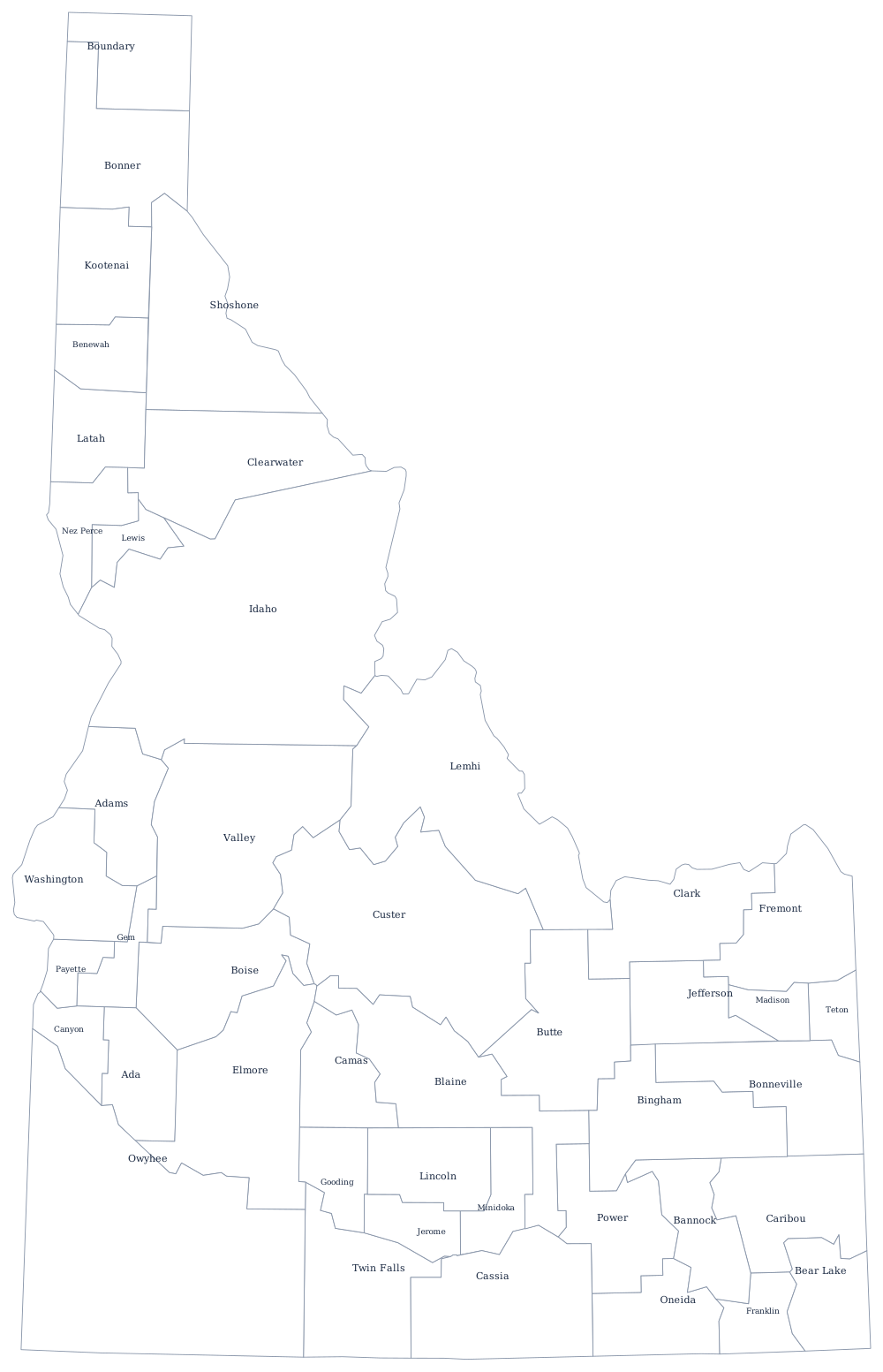
Idaho Territory in 1863 covered what is now Montana and most of Wyoming, and its first counties were mining districts on the Clearwater and the Salmon. As the territory shrank, those enormous early counties were repeatedly split. The result is a state where the county map has two grains: rectangles on the irrigated Snake River Plain, and long north-south strips through the mountains where the only practical boundaries were watersheds.
The 44 counties of Idaho
Ada and Canyon counties are the Boise valley; add Kootenai in the panhandle and those three hold 50% of the state. The top ten together are 76% of Idaho.
| County | County seat | Population (2024 estimate) |
|---|---|---|
| Ada County | Boise | 535,799 |
| Canyon County | Caldwell | 266,892 |
| Kootenai County | Coeur d'Alene | 188,323 |
| Bonneville County | Idaho Falls | 133,644 |
| Twin Falls County | Twin Falls | 96,509 |
| Bannock County | Pocatello | 91,010 |
| Madison County | Rexburg | 55,549 |
| Bonner County | Sandpoint | 53,955 |
| Bingham County | Blackfoot | 50,889 |
| Nez Perce County | Lewiston | 42,847 |
Three commissioners, and a state that is mostly federal
Every Idaho county is run by three commissioners, two elected to four-year terms and one to two years, and every county has an elected sheriff, clerk, treasurer, assessor, coroner and prosecutor no matter how few people live there. Clark County, with fewer than a thousand residents, fills the same slate of offices as Ada County with more than half a million. Several of the smallest counties have tried and failed to consolidate offices, and the coroner's job in particular often goes unopposed or unfilled.
What limits county government most in Idaho is that roughly 62 per cent of the state is federal land — Forest Service, Bureau of Land Management, and the wilderness areas of the central mountains. Counties cannot tax it, so the mountain counties depend on federal payments in lieu of taxes and, historically, on a share of timber receipts. Custer, Lemhi, and Idaho counties are among the most federally owned in the lower 48, which is why they look enormous on the map and raise almost nothing from it.
Largest and smallest counties
Ada County, containing Boise, is by far the most populous at 535,799 in 2024 — 27% of Idaho — and Canyon County next door in the Treasure Valley is second at 266,892. The smallest is Clark County, 794 people in the ranch country north of the Snake River Plain, with its courthouse at Dubois. Idaho County, which runs from the Salmon River wilderness to the Montana line, is the largest by land area at about 8,480 square miles — bigger than New Jersey.
Go up to the Idaho state page or across to the county map index. Bordering county maps: Washington, Oregon, Montana, and Utah. The Snake River page follows the arc that most of southern Idaho's counties are strung along.