US Map / Geography / Rio Grande
Rio Grande Map
For about two-thirds of its length the Rio Grande is not just a river but an international boundary.
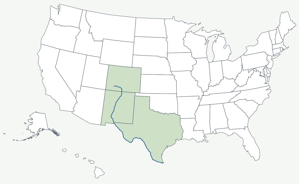
The Rio Grande rises in the San Juan Mountains of Colorado and reaches the Gulf of Mexico below Brownsville, Texas, roughly 1,900 miles later. Mexico calls it the Río Bravo del Norte. From El Paso to the Gulf it carries the international boundary, which means the channel's habit of moving has produced two centuries of diplomacy.
Which states does the Rio Grande cross?
Three. It drops out of the Colorado mountains into the San Luis Valley, then runs the length of New Mexico — through the basalt slot of the Rio Grande Gorge near Taos, past Albuquerque in its cottonwood bosque, and into Elephant Butte Reservoir. At El Paso it meets Texas and the border, and from there it curves through the Big Bend and down to Laredo and the lower valley before reaching the Gulf.
| Source | San Juan Mountains, Colorado |
| Mouth | Gulf of Mexico near Brownsville, Texas |
| Length | about 1,900 miles; figures vary because the channel has been straightened, dammed and rectified in several reaches |
| US states | Colorado, New Mexico, Texas |
| International boundary | about 1,250 miles, from El Paso to the Gulf |
| Main US reservoir | Elephant Butte, New Mexico |
| Name in Mexico | Río Bravo del Norte |
Notable places along the river
Albuquerque is the largest city on the river's American reach, built where the valley widens between the Sandia Mountains and the West Mesa. El Paso and Ciudad Juárez face each other across the channel and function as one metropolitan area split by a treaty line. Downstream, Big Bend National Park takes its name from the great northward turn the river makes through three limestone canyons. Laredo handles more truck freight bound for Mexico than any other American land crossing, all of it over bridges a few hundred feet long.
How a moving river drew an international line
The Treaty of Guadalupe Hidalgo in 1848 made the Rio Grande the boundary, and the river promptly began to disagree. Between the 1850s and the 1860s the channel at El Paso shifted south, leaving several hundred acres of Mexican territory on the American bank — the Chamizal dispute, which stayed unresolved for a century. The Chamizal Convention of 1963 settled it: about 630 acres passed to Mexico, and in 1967 the river was moved into a concrete channel so it could not wander again. The International Boundary and Water Commission has policed the line ever since. Water, not land, is now the harder problem. Irrigation withdrawals leave a long reach below El Paso dry for much of the year, and the lower river is largely rebuilt by the Rio Conchos flowing in from Mexico.
How the water is divided
Two instruments split the flow. The Rio Grande Compact of 1938 apportions the upper river between Colorado, New Mexico and Texas, with New Mexico's obligation measured as a delivery into Elephant Butte Reservoir; Texas has been litigating against New Mexico in the Supreme Court since 2013 over groundwater pumping below the dam that it says intercepts water already counted as delivered. Below Fort Quitman the 1944 treaty takes over: Mexico owes the United States an average of 350,000 acre-feet a year from the Conchos and five other tributaries, measured over five-year cycles, and in dry cycles it has repeatedly fallen behind — which puts Texas irrigators downstream of a shortfall on the Mexican side of the basin.
The other great river of the arid Southwest is the Colorado; the Rio Grande's mouth is the western end of the Gulf Coast, and its upper basin sits between the Rocky Mountains and the Great Plains. See the physical geography of the United States, or the state pages for Texas and New Mexico.