US Map / County Maps / Missouri
Missouri County Map
St. Louis left St. Louis County in 1876 and has spent a century and a half arguing about whether to go back.
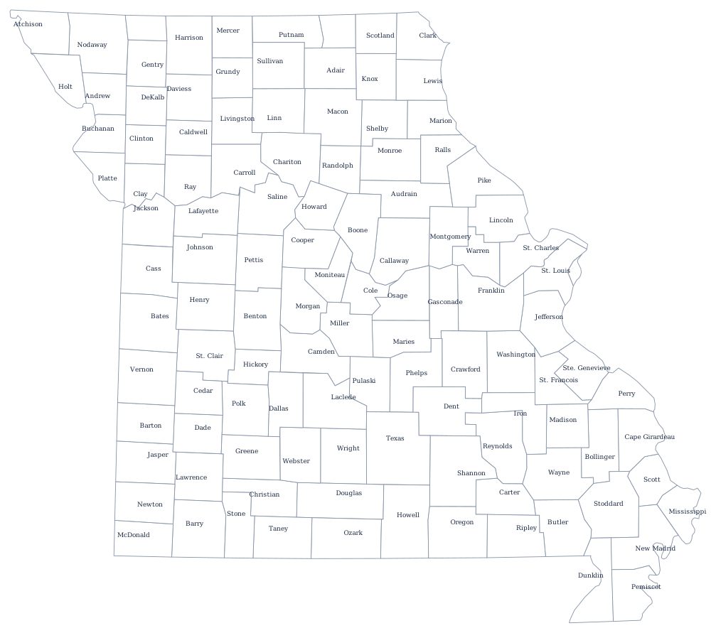
Missouri's first counties were the five districts of Upper Louisiana that the United States inherited in 1804 — St. Charles, St. Louis, Ste. Genevieve, Cape Girardeau, and New Madrid — all of them strung along the Mississippi. Everything else was cut from them as settlement moved west and south, and the last, Worth County, was created in 1861. The Missouri River divides the map as clearly as it divides the landscape.
The 114 counties and one city of Missouri
The ten below hold 59% of Missourians, and they cluster at the two ends of the state: four in metropolitan St. Louis, three around Kansas City. The city of St. Louis appears in its own right because it is not in any county.
| County or city | County seat | Population (2024 estimate) |
|---|---|---|
| St. Louis County | Clayton | 992,929 |
| Jackson County | Independence and Kansas City | 727,362 |
| St. Charles County | St. Charles | 423,726 |
| Greene County | Springfield | 307,942 |
| St. Louis city | Independent city — not part of any county | 279,695 |
| Clay County | Liberty | 263,370 |
| Jefferson County | Hillsboro | 231,888 |
| Boone County | Columbia | 192,154 |
| Jasper County | Carthage | 126,479 |
| Cass County | Harrisonville | 113,873 |
The Great Divorce, and what an independent city costs
In 1876 the voters of St. Louis approved a scheme that separated the city from St. Louis County, fixed the city's boundary at its then-limits, and made it an independent city performing both city and county functions. At the time the county was farmland and the city was paying for it; the boundary has not moved since. The result is a city of 61 square miles surrounded by a county of 88 municipalities and more than 900,000 people, with separate police, courts, assessors, and tax bases. Repeated attempts to reunite them — in 1926, 1962, and again in 2019 — have all failed, usually because county voters said no.
The remaining 114 counties are sorted into four classes by assessed valuation, and the class determines what offices a county must have and how it may be governed; the largest may adopt charters, and St. Louis, Jackson, and a few others have. Kansas City, meanwhile, solved the same problem the opposite way by annexing outward: it now spreads across four counties — Jackson, Clay, Platte, and Cass — and is a city in all of them.
Largest and smallest counties
St. Louis County is the most populous at 992,929 in the 2024 estimates, though it contains no city called St. Louis; its seat is Clayton. Jackson County is second at 727,362 and holds most of Kansas City. The city of St. Louis itself has 279,695, down from more than 850,000 in 1950. The smallest county is Worth County in the far north-west, 1,872 people and the least populous county in Missouri. Texas County, in the Ozarks, is the largest by land area at about 1,180 square miles.
See the Missouri state page for the rest, and the county map index for the other 49. Missouri touches eight states; four of their county maps are Iowa, Illinois, Kansas, and Arkansas. The Missouri River page follows the line that splits the state's county map in half.