US Map / County Maps / Georgia
Georgia County Map
Only Texas has more counties than Georgia, and Texas is four and a half times the size.
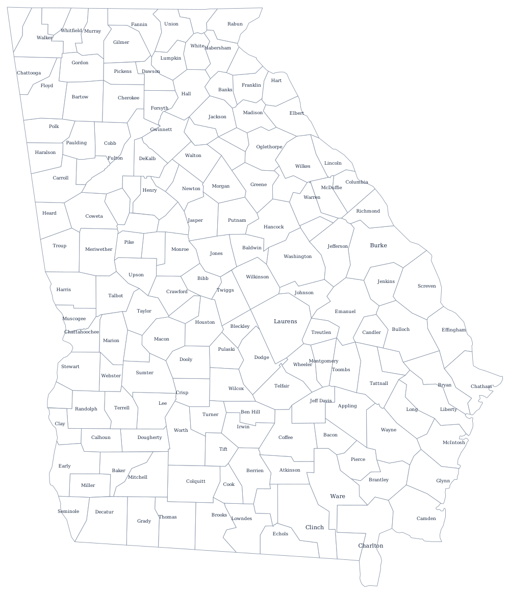
Georgia has 159 counties in 59,000 square miles, an average of about 370 square miles each — roughly a twenty-mile square. The count is not an accident of geography. Georgia distributed its western land by lottery in a series of surveyed districts between 1805 and 1832, and each new tract was organized into counties immediately; then, from 1917 to 1962, the county unit system weighted state primaries by county rather than by population, which made creating a new county a way of creating votes.
The 159 counties of Georgia
Nine of the ten largest are in metropolitan Atlanta; only Chatham, which is Savannah, is not. Together the ten hold 48% of Georgians, while the other 149 counties split the rest.
| County | County seat | Population (2024 estimate) |
|---|---|---|
| Fulton County | Atlanta | 1,090,354 |
| Gwinnett County | Lawrenceville | 1,003,869 |
| Cobb County | Marietta | 787,538 |
| DeKalb County | Decatur | 770,307 |
| Chatham County | Savannah | 307,336 |
| Clayton County | Jonesboro | 297,703 |
| Cherokee County | Canton | 293,513 |
| Forsyth County | Cumming | 280,096 |
| Henry County | McDonough | 259,315 |
| Hall County | Gainesville | 221,745 |
The county unit system and why Georgia has 159 counties
Between 1917 and 1962 Georgia chose its governors and senators through the county unit system: each county cast unit votes, two to six of them, and the eight largest counties together held less weight than a few dozen rural ones. A vote in Echols County was worth roughly a hundred votes in Fulton. The system rewarded any legislator who could split a county in two, and by 1924 the state had reached 161 — the constitution then capped the number at 159. The Supreme Court struck the system down in Gray v. Sanders in 1963, but the county map it produced is permanent.
Three counties have since merged their governments with their cities without losing county status. Columbus consolidated with Muscogee County in 1971, Athens with Clarke County in 1991, and Augusta with most of Richmond County in 1996 — the reason the count sits at 159 rather than 161 is the 1930s abolition of Milton and Campbell counties, both folded into Fulton during the Depression when they could no longer pay their debts. Fulton's odd long shape, running far north and south of Atlanta, is the outline of those two dead counties.
Largest and smallest counties
Fulton County, which holds most of Atlanta, is the most populous at 1,090,354 in 2024, with Gwinnett County close behind at 1,003,869. The smallest is Taliaferro County in the eastern Piedmont, 1,620 people in two small towns, Crawfordville and Sharon, and it has lost more than four fifths of the people it had in 1910. Ware County, in the Okefenokee Swamp country of the south-east, is the largest by land area at about 890 square miles.
The Georgia state page covers the state itself; the county map index has the other 49. Bordering county maps: Florida, Alabama, Tennessee, North Carolina, and South Carolina. The Appalachian Mountains page explains the ridges that end in Georgia's northern counties.