US Map / County Maps / South Carolina
South Carolina County Map
Until 1975 a South Carolina county was governed by the legislators it sent to Columbia, through an annual bill called the supply act.
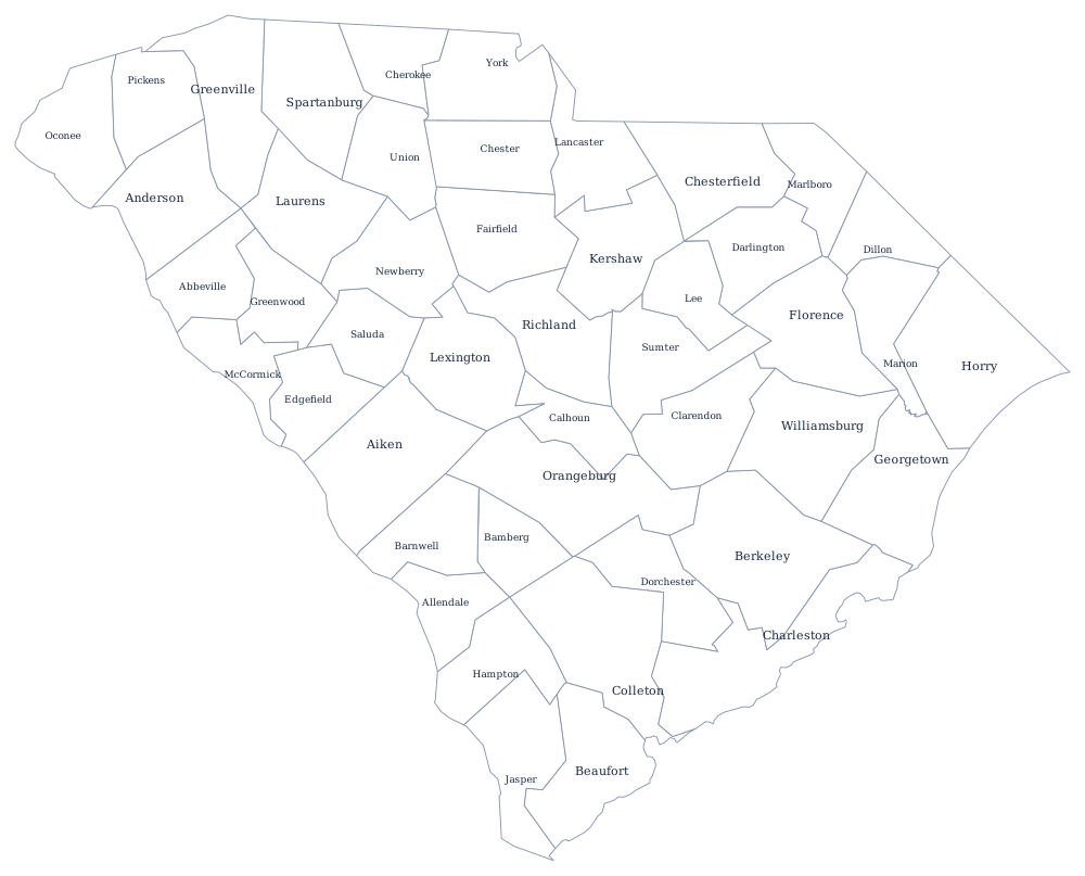
South Carolina has changed the name of its local units twice. Counties were established in 1785, replaced by districts in 1800, and renamed counties again by the constitution of 1868 — which is why an old deed may refer to Pendleton District or Ninety-Six District, places no longer on any map. The modern 46 were fixed by 1919, when Allendale was split from Barnwell and Hampton counties.
The 46 counties of South Carolina
The ten below hold 64% of South Carolinians. Greenville and Spartanburg are the upstate manufacturing belt along Interstate 85; Horry is Myrtle Beach and the Grand Strand, and it has been among the fastest-growing counties in the country.
| County | County seat | Population (2024 estimate) |
|---|---|---|
| Greenville County | Greenville | 570,745 |
| Charleston County | Charleston | 431,001 |
| Richland County | Columbia | 430,651 |
| Horry County | Conway | 413,391 |
| Spartanburg County | Spartanburg | 369,256 |
| Lexington County | Lexington | 313,774 |
| York County | York | 303,001 |
| Berkeley County | Moncks Corner | 264,276 |
| Anderson County | Anderson | 217,183 |
| Beaufort County | Beaufort | 201,775 |
The supply bill, and the Home Rule Act of 1975
For most of the twentieth century South Carolina counties had almost no independent authority. Each county's budget was written as a supply bill and passed by the General Assembly, and the county's legislative delegation — the senators and representatives elected from it — effectively ran local government, appointing boards and directing spending. A state senator was the most powerful figure in his county by a wide margin. When one-person-one-vote rulings in the 1960s broke up the county-based Senate districts that made the system work, the arrangement became unworkable.
The Home Rule Act of 1975 replaced it. Every county elects a council, and each chose one of five statutory forms — council, council-supervisor, council-administrator, council-manager, or council-elected executive — with the council-administrator form now the most common. The change was real but incomplete: the General Assembly still legislates on local matters, school district boundaries in several counties remain set by state law, and counties depend heavily on the state for revenue because the 2006 Act 388 shifted owner-occupied school property tax to the sales tax.
Largest and smallest counties
Greenville County in the upstate is the most populous at 570,745 in the 2024 estimates. Charleston County is second at 431,001, and Richland County, which contains Columbia and the state capital, is a close third at 430,651. The smallest is Allendale County in the Savannah River lowcountry, 7,551 people in a county that has lost population in every census since 1950. Horry County is the largest by land area at about 1,130 square miles.
The South Carolina state page covers the coast and the upstate, and the county map index covers the rest of the country. South Carolina touches only two states: North Carolina and Georgia. Further afield, Virginia shows what happens when cities leave counties altogether. The Atlantic Coast page follows the shoreline the lowcountry counties sit on.