US Map / County Maps / Colorado
Colorado County Map
Colorado's county lines were drawn twice — once around the gold camps of the 1860s, once across the homestead grid of the 1880s — and the two patterns meet at the Front Range.
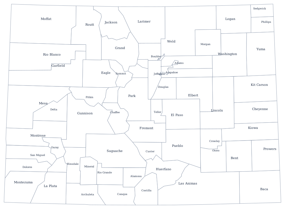

Colorado's mountains and plains produced two different county maps. In the San Juans and the central Rockies the boundaries were drawn around mining districts in the 1860s and 1870s, so they wander with the terrain and enclose oddly shaped pockets of high country. East of Denver, where the land was surveyed before it was settled, counties are rectangles with almost no reference to anything on the ground except the occasional creek.
The 64 counties of Colorado
The ten largest hold 82% of all Coloradans, and eight of them sit in the hundred-mile strip between Fort Collins and Pueblo. El Paso County has overtaken Denver as the most populous, a switch that happened in the 2010s.
| County | County seat | Population (2024 estimate) |
|---|---|---|
| El Paso County | Colorado Springs | 752,772 |
| Denver County | Denver | 729,019 |
| Arapahoe County | Littleton | 666,918 |
| Jefferson County | Golden | 578,533 |
| Adams County | Brighton | 542,973 |
| Douglas County | Castle Rock | 393,995 |
| Larimer County | Fort Collins | 374,574 |
| Weld County | Greeley | 369,745 |
| Boulder County | Boulder | 330,262 |
| Pueblo County | Pueblo | 169,866 |
Two counties that are also cities
Colorado has two consolidated city-counties. Denver became one in 1902, when a constitutional amendment pulled it out of Arapahoe County and gave it a single government for both roles — which is why Arapahoe County's seat is Littleton and why Denver's boundary has grown in awkward annexed fingers ever since, including the salient out to Denver International Airport. Broomfield became the second in 2001 for a more practical reason: the city had spread across four counties at once, so residents on one street paid taxes to Adams and their neighbors to Boulder, Jefferson, or Weld. The legislature and the voters solved it by carving out a new county.
Everywhere else a three-member board of county commissioners runs things, elected by district but voted on county-wide. Home-rule counties may adopt a charter and restructure, but only Pitkin and Weld have done it. The state's Taxpayer's Bill of Rights caps what any of them can collect without a vote, which is why so many Colorado county ballots carry de-Brucing questions asking permission to keep revenue already raised.
Largest and smallest counties
El Paso County — Colorado Springs and Fort Carson — is the most populous at 752,772 in 2024, just ahead of Denver County with 729,019, which is the city of Denver exactly. The smallest is Hinsdale County, 747 people in the San Juan Mountains, where the only town is Lake City and the county has no traffic signal. Las Animas County in the south-east is the largest by land area at about 4,770 square miles, very nearly the size of Connecticut.
The Colorado state page puts these counties next to the state's cities and mountain ranges, and the county map index lists the rest. Neighboring county maps: Wyoming, Nebraska, Kansas, and New Mexico. The Rocky Mountains page explains the divide that splits the state's county map in two.