US Map / County Maps / Wisconsin
Wisconsin County Map
Menominee County was created in 1961 out of a single Indian reservation, and it is still the newest county in the Midwest.
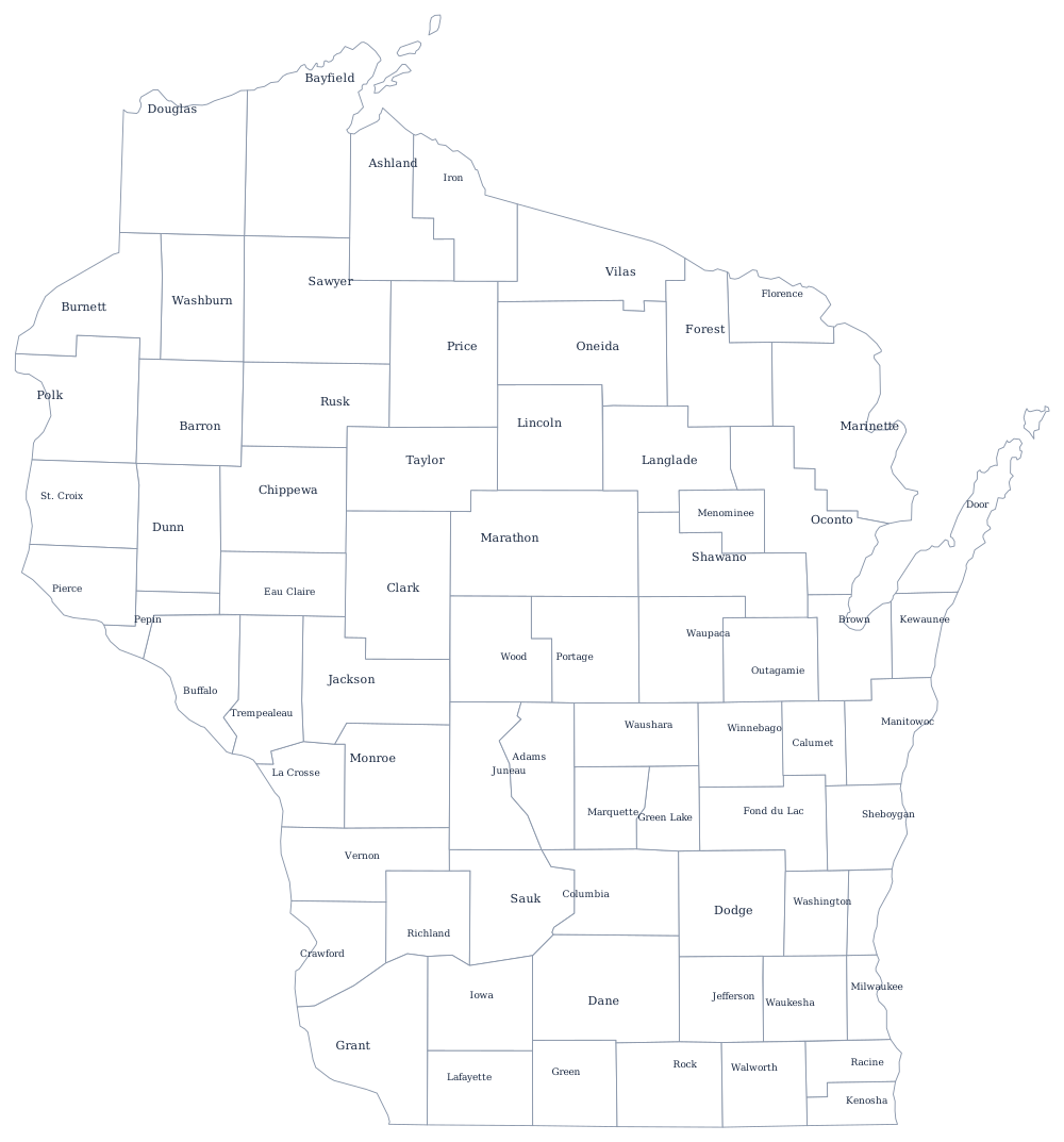
Wisconsin's counties were created from the south upward as the lead-mining district and then the farm counties filled, and from the 1850s onward as the pine forests of the north were logged. Milwaukee County dates from 1834, when the area was still part of Michigan Territory. The northern counties were often organized on the strength of a sawmill and a railroad, and when the pine ran out they were left with land nobody wanted.
The 72 counties of Wisconsin
Milwaukee and Dane — Milwaukee and Madison — are the only counties over half a million, and Dane has been growing while Milwaukee has not. The ten below hold 54% of Wisconsinites.
| County | County seat | Population (2024 estimate) |
|---|---|---|
| Milwaukee County | Milwaukee | 924,740 |
| Dane County | Madison | 588,347 |
| Waukesha County | Waukesha | 417,029 |
| Brown County | Green Bay | 273,909 |
| Racine County | Racine | 198,651 |
| Outagamie County | Appleton | 195,390 |
| Winnebago County | Oshkosh | 173,307 |
| Kenosha County | Kenosha | 168,754 |
| Rock County | Janesville | 165,461 |
| Marathon County | Wausau | 139,091 |
Menominee County, county forests, and very large boards
Menominee County is the youngest county in Wisconsin and one of the youngest in the country. Congress terminated federal recognition of the Menominee tribe in 1961, and the reservation, which had been held in trust, was converted into a county and a single town with identical boundaries. Termination was a disaster — the tribe lost its hospital and much of its land base — and federal recognition was restored in 1973, but the county remained. It is the only county in Wisconsin whose population is majority Native American, and it is both the least populous county in the state and the one with the fewest square miles of taxable property.
The northern counties own an unusual asset: about 2.4 million acres of county forest, land that was tax-delinquent after the logging boom collapsed and that counties took over in the 1920s and 1930s under a state program. Those counties still manage the timber and take the revenue. Wisconsin county boards are also among the largest in the country — supervisors are elected from small single-member districts, so a county of 100,000 may have thirty or more of them, and the legislature has more than once made it easier for a county to shrink its board.
Largest and smallest counties
Milwaukee County is the most populous at 924,740 in the 2024 estimates and contains Milwaukee; Dane County, which contains Madison and the state capital, is second at 588,347 and has been closing the gap for two decades. The smallest is Menominee County, 4,286 people on the Menominee reservation. Marathon County, in the center of the state, is the largest by land area at about 1,545 square miles.
Go up to the Wisconsin state page or across to the county map index. Bordering county maps: Minnesota, Iowa, Illinois, and Michigan. The Lake Michigan page follows the eastern shore that eight of these counties sit on.